Sine City
In this project, we used Trigonometry, Geometry, and other math concepts to redesign San Marcos Blvd., a street outside our school. Each class in the 11th grade got a block to redesign, and each group of 3-4 students got a plot of land on that block. This project is actually something that the city of San Marcos is already pursuing, called the "Creekside Development Plan". They have a set of documents on their website with various restrictions, recommendations, and inspirations for the project. Things like the minimum and maximum heights for buildings based on their zones, the building setbacks (how far back from the street the buildings were), and the floor area ratio (how much building floor space we could have based on how much total space was on our plot).
During the project, we designed our plot of land from start to finish. First, we had to actually go to our plot and do a Site Analysis. In the Site Analysis, we measured our plot using Trigonometry (our plot was private property, so we couldn't go on it to hand measure), and we also took a look at what was already there: the Green Thumb nursery. We decided that the nursery had to go - it didn't go along with any of San Marcos's standards - and began designing our buildings. In this stage of the project, we had to keep in mind all of San Marcos's rules, and design principles such as the Golden Ratio, to keep our buildings within code, and looking nice. We went through many iterations of our plot, always changing some minor issue, and causing or discovering another one. Finally, once we finished with the hand-drawn designs, we moved on to our digital drawings. We actually made 2D drawings for each side of our building using Adobe Illustrator, and laser cut them out. In the end, we put all of the models together, and had a scale model of the entire street. One last thing that my group did as an honors option was adding Arduino based LED street lights to our final product.
During this process, we learned a ton about urban planning and architecture. We had to make buildings that were the right size for people, and had to make them useful as well. We also had to adhere to all of the city's plans, which is definitely something architects do all of the time. We also learned about engineering, in that we had to design and fabricate our ideas, then present them at our exhibition. My group also did engineering with our LED lights.
During this process, we learned a ton about urban planning and architecture. We had to make buildings that were the right size for people, and had to make them useful as well. We also had to adhere to all of the city's plans, which is definitely something architects do all of the time. We also learned about engineering, in that we had to design and fabricate our ideas, then present them at our exhibition. My group also did engineering with our LED lights.
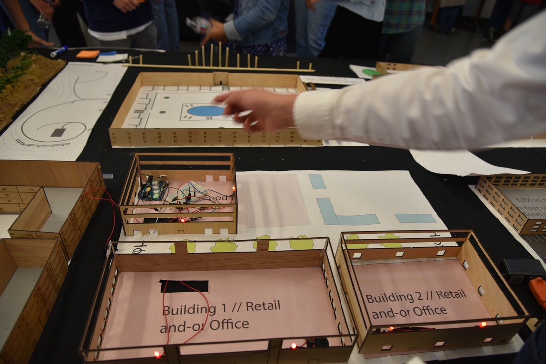
Our final product on exhibition night (feat. Matthieu's arm)
We incorporated all of the city’s requirements into our building design. We paid special attention to the floor plan ratio, the minimum and maximum building heights, the building setbacks, and the building use requirements. The floor plan ratio is a restriction that made us pay attention to our building’s square footage versus the ratio they gave us. The minimum building height for our area was 3 floors, which is what we chose to use. The maximum height was 5 floors. The setback was a restriction that told us how far back from the street we could have our buildings. Finally, the use requirements said that we could only use the buildings for retail or food on the first floors, and housing or offices on the upper floors.
The golden ratio is used seven times in the overall plan view. The food building (building #3) is split so that the patio is just more than 40% of building #3’s area. Building #2 ‘s Eastern edge is located at just over 60% of the entire plot’s Western length. The park also features the ratio in four parts: the Western length placement of the water features, and then within the placement and spacing between each piece of the feature. Lastly, the Southern edge of building #2 reaches just under 40% of the Western length.
It is used three times in each of the elevation views. It is used two times to define the center of building #1. All of the windows are placed right above 60% of each building’s height.
We incorporated the sun path analysis by putting the majority of our windows on the South side, which will get the most sun in the Winter, and will be protected by our custom awnings in the summer.
Finally, we chose the overall design we did because we wanted to make our space as efficient as possible. We included three buildings total, two of which are retail, and one of which is for food, and includes a patio. The city put a park in our plot as well, and so we included that, along with a water feature.
